GUIDE
- Getting Started
- Building Radiuses of Postal Codes
- Uploading Postal Code Lists Via Excel File
- Entering Postal Codes Manually
- Managing and Editing Postal Code Lists
- Implementing Geolocation Targeting by Country, State/Region, City, or Postal Code in Campaigns
- Geolocation Discrepancies
Getting Started
Geolocation is a required component of all campaigns within Choozle and is set at the ad group level. All countries, states/provinces/regions, and cities/DMAs are available directly within the Choozle platform. For more granular targeting, postal code lists can be created and uploaded into the platform for any country that has a uniform postal code system.
As a result of the recent privacy legislation in Virginia, Connecticut, and Washington, our ability to execute geoframing or offline attribution within these states has been restricted. While real-time geofencing remains an option, functionalities such as targeting with a lookback window and tracking offline visit feeds are no longer viable in these regions.
Building Radiuses of Postal Codes
- Go to one of the many websites available online with free radius targeting. We like this site, Free Map Tools.
- Input the location you are targeting and the radius you wish to include.
- The map will repopulate to show the new radius.
- Copy the zip codes listed that fall within the radius.
Uploading Postal Code Lists via Excel File
- Navigate to Libraries > Geolocations List.
- Click the + icon in the light gray sub-navigation bar to add a geolocation list.
- Give the geolocation list a name.
- Click Download Template to download the geolocation template.
- Once the template has been downloaded and opened, it will, by default, open on the second tab of the workbook, which contains the acceptable country codes for each country.
- To complete the template, navigate to the first tab ("Zip Codes"), complete Column A ("Country Code") with the corresponding country code from the "Country Code Legend" tab of the workbook, and enter one uniform postal code per row in Column B ("5 Digit Zip Code"). See note below regarding Canadian postal codes**.
- Once the template has been completed, click Upload Excel File and select your file from your computer to upload.
- Click the blue Add button. The zip codes will populate in the box on the right side of the screen.
- Click the red X next to any zip code to remove it.
- Optionally, enter any notes about the list and then click Save.
**NOTE: For Canadian postal codes, only enter the first 3 characters of the postal code.
Example: A1A 979, should be entered as A1A
Entering Postal Codes Manually
- Navigate to Libraries > Geolocations List.
- Click the + icon in the light gray sub-navigation bar to add a geolocation list.
- Give the geolocation list a name.
- Select a country from the dropdown.
- Type the desired postal codes into the box, with one postal code per row.
- Click the blue Add button. The zip codes will populate in the box on the right side of the screen.
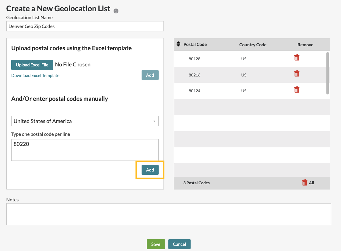
- Click the red X next to any zip code to remove it.
- Optionally, enter any notes about the list and then click Save.
Managing and Editing Postal Code Lists
- From the Geolocations Library dashboard, type a postal code list's name into the search box to search for the list.
- Click Edit next to any postal code list to view or to edit its contents.
Implementing Geolocation Targeting by Country, State/Region, City, or Postal Code in Campaigns
- Navigate to the Campaigns dashboard.
- Scroll down to the campaign that houses the ad group you will be using and select Action > Edit.
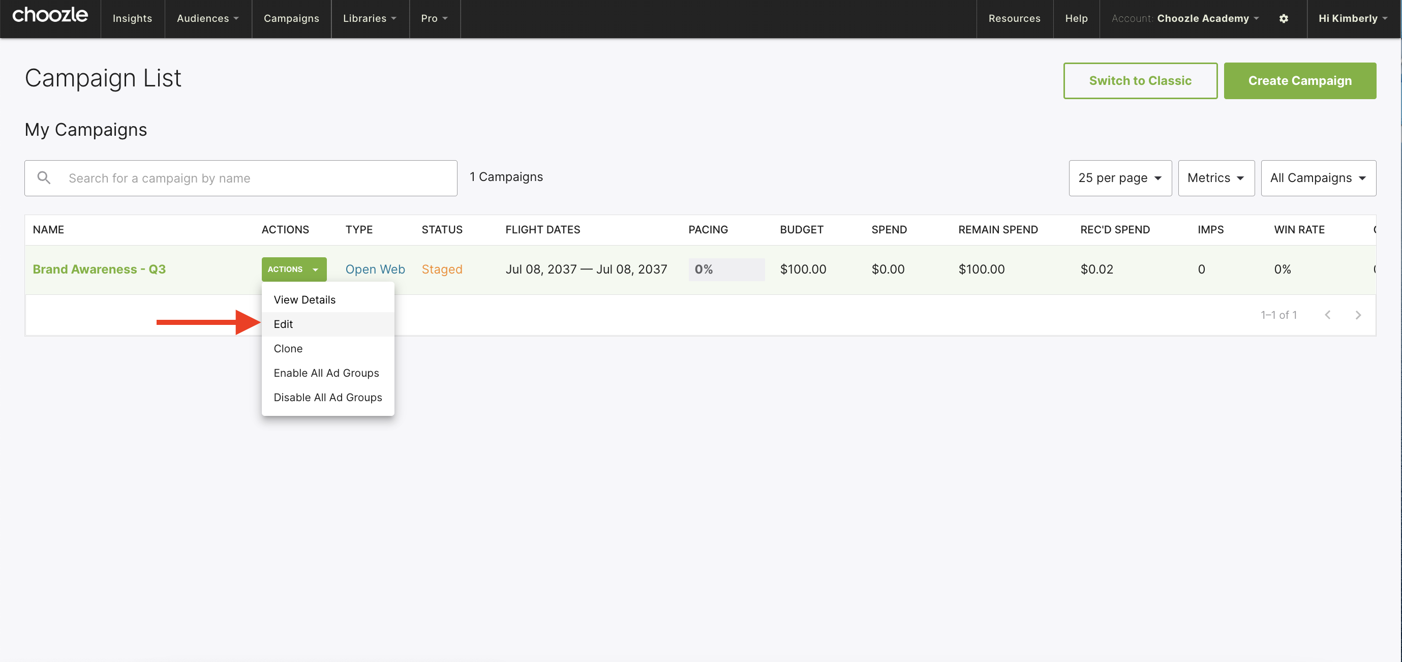
- Navigate to the Ad Group settings by navigating to the campaign’s “Action” button and selecting “Edit.” From the Edit Campaign screen, scroll to the Ad Group in question and click the green Pencil icon in the right-hand corner.
- Scroll down to the target audience section of your ad group.
- Type the name of the desired country, state/province/region, city, or custom postal code list into the Geolocation Library.
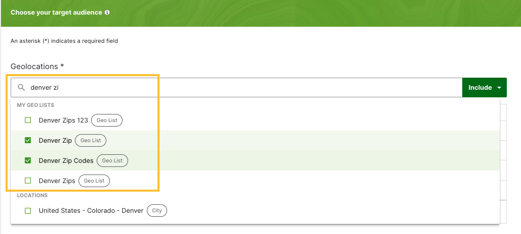
- Select the location(s) and save your ad group.
Geolocation Discrepancies
Our geolocation provider is MaxMind, a service that maps IP addresses to cookie profiles by referring to data from a variety of sources, including their own, independently-collected data from their miniFraud network and large corporations who pass millions of actual end-user locations to them daily. Thus, they know exactly where many IPs are located in virtually real-time with an estimated 99.8% accuracy rate. Furthermore, our exchange partner completed an extremely thorough three-point analysis to match IPs to geolocations, which all agreed with each other, and we are always refreshing and updating our geolocation database for accuracy.
Need Help?
If you have any additional questions please reach out via your Customer Support Portal!